Pembrokeshire day four – 10th Oct 2011
Day four itinerary
Breakfast 0800.
Pay bills and pack coach.
Walk to Tenby North Beach 0900.
Finish at Tenby South Beach 1130.
Lunch in Tenby.
Leave Tenby 1330.
Arrive Splash car-park 1630-1700.
Write up of day four by Cec Roberts
The field trip was researched, planned and led by Alan Gray, a member of Malvern U3A Geology Group. For is introduction, without pictures, click here.
Alan set the scene in the comfort of the hotel lounge, distributed a hand-out, with many technical details and began by outlining the geological history of Tenby. In his own inimitable style, he explained that we would start our field visit at the northern end of North Beach, examine and discuss the cliff exposures and rocks on the sands, walk past the harbour and over Castle Hill to the far end of South Beach.
Alan had planned a walk to first see the younger Carboniferous Millstone Grits exposed along North Beach and go on to the earlier Carboniferous Limestones at the southern end of South Beach. He also explained that, as a result of the Variscan Orogeny, the whole geological sequence of the North Beach was extremely complex and often confusing with extensive folding, faulting, and thrusting with many anticlines and synclines. We would also see some fossils, Precambrian beach armour and caves formed by differential erosion of the mudstones in the cliffs on South Beach. Alan also talked about methods of assessing the right way up of strata, which would become significant later. He also mentioned that Britain was on the equator during the Carboniferous and that there was continental glaciation at the South Pole which had an affect on the geology of Tenby.
What follows is a brief introduction, then an account of what we actually saw and discussed during the field visit.
Basic Introduction to the Geology of Tenby.
Factors which had a significant impact on the complex geological structures seen in the Carboniferous rocks exposed at Tenby are...
1. Tenby was on the equator during the Carboniferous Period:- 363 to 290Ma. In the early Carboniferous, shallow-water tropical carbonates (limestones) were laid down in the warm seas of the Rheic Ocean, followed by the Millstone Grits and then the upper Carboniferous Coal Measures which lie further to the north.
2. The Variscan Orogeny, which took place over a period of about 70 million years had profound effects in Pembrokeshire, with compression from the south causing the rocks to be intensely thrusted and folded. Tenby was on the Varsican front, not a narrow line, but a regional band of disturbance over a distance of perhaps 50 miles. This caused the complex thrusting and folding resulting in the anticlines and synclines present around Tenby today.
3. The Ritec Fault trends east-west from Milford Haven and terminates in splayed ends at Tenby. This is on a line of weakness of an earlier fault, which may have originated in the earlier Caledonian Orogeny, and became active again during the Carboniferous Period.
4. The Rheic Ocean was closing to the south. By the end of the Carboniferous the ocean had closed, followed by the Variscan Orogeny, and Britain was uplifted and lay in the arid heart of a super continent Pangea.
5. There was an ice age from the early Carboniferous through to the late Permian. Alternate advances and retreats of the ice sheets and the associated falls and rises in sea level are probably responsible for the cyclic nature of sedimentation.
6. St. Georges Land lay to the north and deltas formed by rivers, which flowed from the eroded land-mass, to form the Millstone Grits on North Beach.
NORTH BEACH:
Location Map
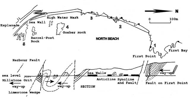
In general the strata of the rocks on North Beach tend to dip and young to the south, contrary to the regional trend of younging to the north. Therefore one would expect to find younger rocks further to the south, but the rocks exposed on South Beach are the older, earlier Carboniferous limestones. An explanation for this apparent mystery is that blocks of southward dipping strata are consistently thrust upwards and northwards over younger blocks. As a result, progressively younger rocks occur in a southward direction
The picture is confusing, but nevertheless the evidence is there on North Beach. It is not easy to imagine a mechanism for this, but it is understood from what we see today, the rocks are the eroded remains of a complex thrust fault system. It is the sort of structural complexity that may result from piggy-back forward propagation of the active thrusts in which a series of imbricate thrust slices or blocks are produced.
Location 1.
Alan having whet our appetite, we then set off from the hotel and descended the zig-zag path, with much anticipation of what we were about to experience. On North Beach we headed out over the sands to First Point, the starting point for our visit.
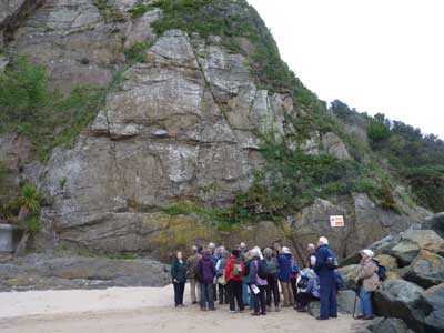
This looked like the start of something good! The huge slabs of the near vertical Telpyn Point Sandstone were fractured and secured with rock bolts. Standing back we could see that this was the southern limb of an asymmetrical syncline, there was a significant angular difference in the bedding planes of the northern limb of the syncline. There was much discussion regarding the actual position of an undulating fault but concluded that it appeared to run down through the centre of the syncline.
The ironstone pebble lag at the base of the unit raised many questions and promoted discussion... was it a conglomerate or was it a breccia? was it matrix or pebble cast supported? and what is a lag? The consensus of opinion was that it looked more like a matrix supported conglomerate with mixed rounded or sub-angular clasts. The conglomerate contained many large pebbles which suggests that it was left behind (lag) in a high energy environment as rivers flowed into a delta from land to the north. An exposed shelf on the base of the unit was plunging south eastwards down towards the beach.
Location 2.
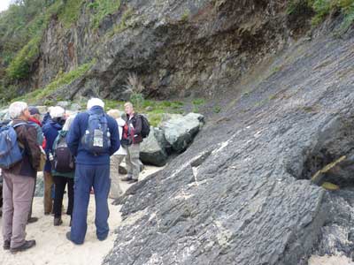
Alan pointed out features and various exposures, including sequences of mudstones, siltstones and thin sandstones along the North Cliffs as we progressed southwards. The strata generally dipped to the south as explained above. It was mentioned that geologists make use of depositional environments and other features to determine the "right way up" of strata. "Fining upwards" is indicative of sedimentation in fluvial channels whereas "coarsening upwards" indicates deltaic deposition.
We had a close look at an exposed face of a mudstone which was also dipping south at an angle of about 45 degrees, desiccation cracks could be clearly seen on the surface. These cracks probably occurred over a period of a few days as the mud was sun-baked, it was subsequently “fossilised” by being compressed into mudstone. Alan also pointed out that the cracks appear to be wider at the top, which is another indication that the structure is "the right way up".
There was some discussion regarding geologists studying modern day depositional environments. It was thought that research work was being done, but in general it was not part of normal course work. There was also some discussion on other dating methods. Fossil horizons give comparative age which can get down to the Precambrian base using trace fossils, burrows etc. It was said that volcanic exposures give a more accurate method of actual dating.
As we walked along the beach we saw the eroded remnants of anticline and syncline features. It was pointed out that the eroded remains of one particular rock in-situ on the beach was at the same angle as the rocks in the cliff and was therefore part of the same structure. This promoted some discussion on erosion by wind, waves and beach pebbles etc.
Location 3.
Further along we had a close look at the sea defences, these rocks were Precambrian diorite, quarried from the Johnston thrust fault complex and dated at about 650Ma. Epidote could be seen on the surface of some rocks.

Nearby we saw a loose mass of rocky detritus, which had been eroded from the cliff face by water, ice or wind. Alan explained that it was at or near the angle of repose which is determined by the size and type of the particles in the detritus.

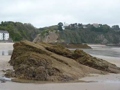
Further on at the southern end of north cliffs there is a sandstone exposure, it was pointed out that the sandstone beds here are similar to those on Gosker Rock the large rocky outcrop on the beach to the south-east. Therefore, there must be a wrench fault between the two sandstones.
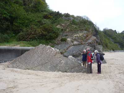
Location 4.
At Gosker Rock we examined the southwards dipping siltstones and sandstones from all angles. Which way up is it? Load casts could be seen on the underside of the north face and there is some evidence of ripple marks. There has been much debate about this in the past, but it is the right way up! Just to the south are the splays of the Ritec Fault, these were discussed in some detail.

The exposed, in situ rocks on the beach to the south of Gosker Rock are the limbs of a miniature syncline. Alan discussed methods of tracing lines of faults - "a large hammer and a line of seismometers" to find structures beneath the surface and also looking at a line of sight on the face of angled blocks. It was pointed out that faults can form unexpected features on the landscape and are not always easy to identify at the surface.
Location 5.
Barrel-post Rock is the tip of a fault wedge of Carboniferous limestone shales with sandstones, which has been thrust into position between splays of the Ritec Fault.
SOUTH BEACH:
Location Map

Location 6.
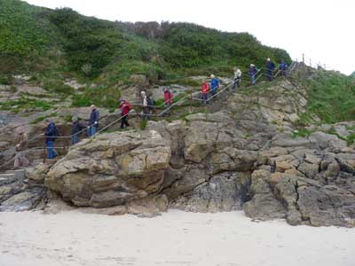
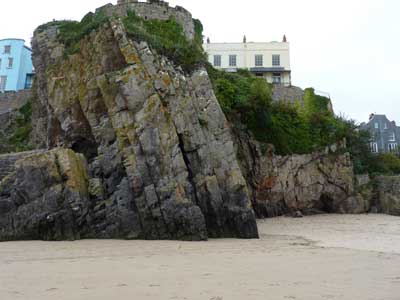
We walked around the harbour and over the southern end of Castle Hill crossing the main splays of the Ritec Fault. The fault passes just to the north of St. Catherine's Island. The fort is a “Palmeston Folly” built of Carboniferous limestone. We proceeded down the steps onto South Beach. The rocks here were carefully examined, they are on a shear plane of the Ritec Fault and have undergone much disturbance. The fault rock was considered to be a wide belt of very angular fault breccia with visible fragments surrounded by a matrix with red stained calcite veins. It was noted that fault breccia include clasts which have been fragmented due to the movement on the fault plane, and the fragments, unlike other breccias remain close together.
Location 7.
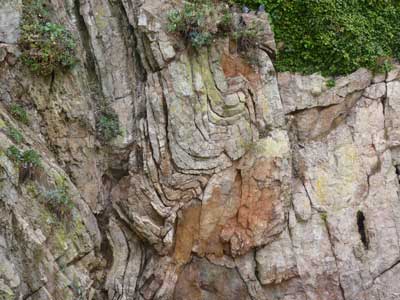
Here, we are on the northern limb of the Tenby anticline. The east-north-east trending anticline displays a dominant feature in the cliffs of South Beach. A small buckle fold could be clearly seen in the High Tor Limestone. Two thrust planes one horizontal and one angular could also be seen plunging down towards the beach. A large fissure had opened up on the northern flank of the limb and was filled with loose mixed angular material in a matrix, which had been eroded away at its base to form a small beach cave.
Location 8.
Alan pointed out more features in the cliffs as we walked past the core of the Tenby Anticline which is plunging down towards the sea and is cut by a small
thrust.
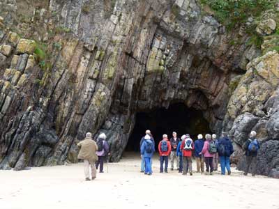
Location 9.
Here the softer mudstones have been eroded away to form a prominent cave, the strata above has been stabilised with rock bolts and wire netting. The Caswell Bay Mudstone Formation represents a lagoonal phase, which shows signs of bioturbation (worm burrows) and it is said there is "chicken wire" anhydrite, which is typical of today's sabka environments, but this was not in evidence. At
the northern side of the cave entrance, the base of the lagoonal facies rests on a palaeokarst surface (similar to the limestone pavements of North Yorkshire) this marks the top of The Gully Oolite. The oolitic limestones here are much different to those found in the Cotswolds. The cliffs to the south are the High Tor Limestone.
Some additional features were pointed out; a reddish vein, running through the unit was probably formed above sea level during a period of exposure, and to the south of the cave entrance, there was a small slump fold but the sedimentation immediately above was not folded. An erosional base was also seen.
Location 10.
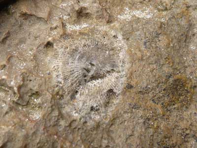
Further south we came to a section showing weathered coral fossils, it was explained that this section was formed during a period of shallow seas and maybe a period of exposure which would account for the fossil erosion.
Location 11.
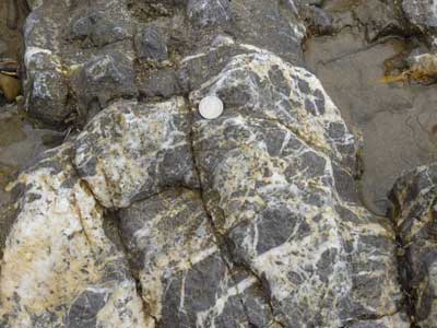
A little further on, an almost vertical bedding plane in the limestone is exposed near the steps, showing grooved calcite mineralised slickensides. The surrounding veined limestones are indicative of a fault, causing brecciation which is in-filled with calcite. Brachiopods can be seen in the limestone just above the base of the Hunts Bay Oolite near the steps.
Location 12.
At this section, in a gully in the cliff face the Hunts Bay Oolite was examined, it is composed of many thin shoaling-upwards cycles. The cycles have been interpreted as high-energy shoals passing upwards into lower-energy inter-tidal facies, with stromatolites.
Location 13.
We are now at the southern end of South Beach and at the end our journey. We are at a cleft in the Hunts Bay Oolite; here we see irregular veins of crystalline calcite which infill fissures and cement together detached blocks of limestone and fault breccia. There are also many open fissures with loose blocks wedged in place. A limestone bed near the cliff top is crowded with valves of giant brachiopods and there are others nearby in the base of the cliff. Nearby, inside a small cave can be seen layers of calcite plus a fine red and buff sediment and above the entrance a buff coloured collapse breccia (gash breccia) deposit, interpreted as Triassic pothole and fissure fills.
Summary
On day two: Our first field trip, we saw the oldest rocks in Pembrokeshire the Precambrian, Cambrian and the Ordovician at Whitesands Bay and St Davids Head. Day three: In misty conditions and gale force winds, we saw the towering cliffs of the Silurian at Marloes Sands, and the folded O.R.S at St. Anne's Head. Day four: It was Tenby, which exceeded our expectations, where we saw the
youngest rocks in Pembrokeshire, the Carboniferous. Surely the icing on the cake and truly amazing rocks in terms of their geological interest, diversity and complexity along both North and South Beach.
There was much interest, many questions, and a lot of discussion but not always agreement: this meant that it was not possible to cover the planned route in the time allowed, but we continued on, to perhaps the most interesting section at the end of South Beach, where we finished our visit at about 12.30pm. There was still ample time for a snack lunch before picking up the coach for our return journey to Malvern at 1.30pm.
We must give our thanks to Alan Gray for his guidance, knowledge and enthusiasm, for a well researched and well structured event which made the visit such a resounding success. We were also very fortunate to have two geologists within our group who were able to answer many questions and point out additional features; therefore we must also thank John Payne who has much local knowledge and Richard Edwards who has a wealth of geological expertise.